Explore Errus
— The Relics of Errus by Gordon Greenhill
TAP area on MAP to learn about…
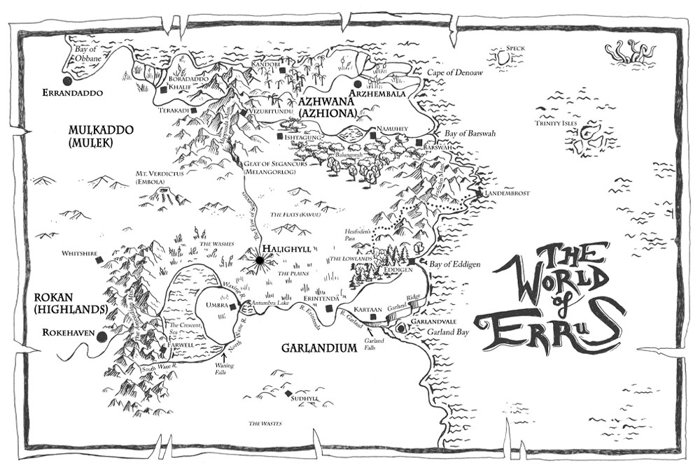
The Nations of Errus
Garlandium
Garlandium is the largest kingdom in Errus based on square miles. It is bordered on the north by the Flats of Kavue and the south by the snowy Wastes. Militarily known for strong horsemanship and seafaring, they have been in a state of war against northern Azhiona for eight centuries. While once monotheistic, they have in recent centuries become mostly polytheistic, worshiping the Celestial Emissaries.
Principle Cities
- Garlandvale — The capital of Garlandium, the palace and royal city sits upon a man-made tidal island just off the coast in Garland Bay. A massive causeway connects it to the mainland, where lie the broader city suburbs. The vale itself is an ancient comet impact site with high cliffs forming a circular depression many miles wide, like a crown or wreath around the point where the city center now is— hence the name. At the height of this natural wall, called the Garland Ridge, the Garland Falls plummet to the bottom of the vale and flows into the ocean. Great iron sea fortifications were built up so that the royal palace could set directly at the mouth of the river without being eroded away. Massive elevator systems built into the Ridge can hoist goods and people from the floor of the vale to the top of the ridge to and from the supply city of Kartaan.
- Halighyll — Literally “The Holy Hill,” Halighyll is the center of religion and science in Garlandium, which are seen as related branches of knowledge, the former being more theoretical-exploratory, the later a practical venture. It was also a great cultural center until the Flow of Segancurs ran dry many centuries ago. This river flowed from the Alappunda mountains in Azhiona across the Plains of Kavue and supplied the city. It has been traditionally held that he Azhionians blocked up the river at its source as a siege tactic. But a few questors also speak of the legend of Vizuirtundu, a well deep in the mountains of Azhiona that was the source of the stream.
- Farwell — A foundry city near the head of the South Wane River at the foot of the Aracadian Mountains. Host of great iron works, it is the major industrial center of the nation. It supplies iron and luxury goods to the rest of Garlandium. It is heavily populated by dislocated Rokans, who serve as a labor class beneath a more prosperous Garlandian constituency.
- Landembrost — On the eastern most tip of the continent, Landembrost is the exclusive point of contact between Garlandium and Azhiona. The city is divided into a northern Azhionian half and a southern Garlandian half, both heavily garrisoned with troops. Although guarded commerce (mostly under the supervision of Mulkadese Merchant Guild) is permitted in the demilitarized area call the Sands, citizens of neither empire are permitted in the opposite half of the city on pain of death. The city is also a minor sea port, although limited due to its lack of natural harbor and promonitory elevation overlooking the ocean.
- Umbra — A great trade center in the crook of the Crescent Sea where the North Wayne River empties into Antumbra Lake. A northern channel was constructed long ago and christened the Waxing River to enable ships to sail directly from Farwell to Umbra, avoiding the falls on the North Wane River and further into the heartland on the River Erintenda.
- Erintenda — A town at the fork in the River Erintenda, where shipping proceeds both down the man-made Erintenda branch to Eddigen as well as east as the River Garland toward Garlandvale.
- Eddigen — The principle sea port of Garlandium, located in the Bay of Eddigen.
- Kartaan — A fortified supply town at the top of the Garland Ridge.
- Sudhyll — The southern-most city of the nation. Almost entirely enveloped by the expanding Wastes, it is sparsely populated.
Azhwana
A northern nation that lies between the eastern Alappunda Mountains and the sea. Called Azhiona in Garlandium, it is smaller than Garlandium. The Azhwana are a highly cultured and unified people, excelling in poetry, music, and storytelling. With long collective and oral history, they understand the ways of the Longaevi more clearly than their southern neighbors, whom they call the Garlandish. Although they possess cavalry, their military strength lies in the long bow and the long march. They are the most rigorously monotheistic of the nations of Errus, believing the Celestial Emissaries to be heretical corruptions of the power of the one God Thes. They have been at war with Garlandium for over 800 years, however, with the expansion of the Flats of Kavue in recent centuries, the conflict has become more of a cold war.
Principle Cities
- Arzhembala — Capital city of the Azhwana at the head of the Mkubwa River delta
- Barswah — Capital of Mashariki Province and principle sea port of the east at the mouth of the Mdogo River
- Namwhey — A resort city on the shore of beautiful Lake Kijani
- Kondobi — Capital of Khaskazinah Province and principal sea port on the north sea
- Ishtagung — Capital of Balungorah Providence
- Landembrost — Eastern most city of the continent, the northern half of the city belongs to Azhwana (See entry under Garlandium)
Rokan
The Rokan highlands are reported to be a dry hard land east of the Aracadian Mountains and very cold. Inhabited by the Rokan people, known in Garlandium as Opsiercoms or “late comers” (or more often by the slur “Opsies”). Many thousands of the Rokan diaspora live and work in Garlandium as part of an underclass of laborers and servants. Most of the Rokan highland eastward is unknown to Garlandian map makers.
Principle Cities
- Rokehaven — The Rokan capital city at the base of the River Holdrae as it passes out of the Aracadian Mountains.
- Whitshire — A minor trade city on the boarder of the Flats at the northern tip of the Aracadian Mountains.
Mulkaddo
A mysterious nation in the northwest of Errus, Mulkaddo is known simply as Mulek in Garlandium. They are not noted for military prowess, but for being philosophers and merchants, thoughtful and honest, but shrewd. A few Mulkadese merchants can be found in nearly every major port city. Beyond these expatriates, however, little cultural exchange exists between Garlandium and Mulek. Much of the nation lies to the north west and is unknown to Garlandian map makers.
Principle Cities
- Errandaddo — The capital, on the Bay of Obbane and principal sea port for the whole nation.
- Boradaddo Kaliff — At the head of the River Tanin [tah-NEEN] delta, it is Mulek’s second largest city.
- Terikkadi — A small town at the base of the River Tanin as it passes out of the Alappunda Mountains.
Geographical Features
The Flats of Kavue
The great desert that separates the north from the south in Errus. Also called the North Belt in Garlandium, the Great Flats, or just The Flats, it was arable grassland many centuries ago when it was known as the Plains of Kavue. In recent centuries is has become an uncrossable sandy waste. It gradual expansion over the years is mainly responsible for the relative cessation of hostilities between Garlandium and Azhiona, as it is now thought impassible.
The Wastes
The snowy Wastes south of Garlandium, also called the South Belt, are the point where the temperate climate of Garlandium gives way to inhospitable cold and ice. Like the Flats of Kavue, they too have been expanding in recent centuries and have rendered the southern city of Sudhyll nearly uninhabitable. Unless the source of this expansion is found and something done about it, Garlandium will continue to lose arable land.
Vizuritundu
Vizuritundu is the Azhionan name for Therra’s Well. The Well, which legend tells, once burst forth from the Alappunda Mountains at the Geat of Segancurs to water the Plains of Kavue as well as Haligyll in the south. Centuries ago the water ceased sparking the Ever-War between Garlandium and Azhiona. It’s location, if indeed it ever existed, is now lost.
Mt. Verdictus
Mt. Verdictus, or Embola as it is known in Azhiona, is a volcano in the Flats of Kavue. A geologic age ago it was part of a common mountain chain running from north to south. The central area has experienced constant leveling and eroding forces, leaving now the Alappunda Mountains in the north and the Aracadians in the south. The isolated preservation of Verdictus is a geological mystery, but it has not been studied due to its inaccessible location deep within the Flats.
The Trinity Isles
The Trinity Isles are a volcanic archipelago of three islands in the northern ocean. The islands – Faedera, Byre, and Frofergast – are claimed by both Garlandium and Azhiona and a source of conflict between the two nations – especially the rich deposits of volcanic wealth on Byre.